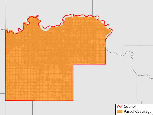
McKenzie County
Parcel Data
Price: $200.00
Last Updated:
2025-Q3
Parcels in County:
18,692
Parcel data available to download as a GDB, GeoPackage, Shapefile, Excel, CSV, or Google Earth KML file.
All purchased data comes with six months of access, including any updates, at no additional cost.
Key attribute coverage for McKenzie County
The percentage of McKenzie County parcels containing the following key attributes:
Owner: 93.5%
Parcel Number: 99.8%
Acreage (Calculated): 100%
Site Address: 36.7%
Mailing Address: 84.8%
All available attributes in McKenzie County
Parcel Number
Site Address
Owner
Acreage (deeded)
Acreage (calculated)
Perimeter
Municipality
School District
Zip Code
Flood Zone
Flood Zone Subtype
Census Tract
Census Block Group
Census Block
Land Market Value
Building Market Value
Mail Address1
Mail Address2
Legal Desc1
Legal Desc2
Legal Desc3
Buildings
Addr Sec Unit Num
Place Gnis Code
Land Cover
Elevation
Owner Occupied
Robust Id
Usps Residential
Plss Description
Plss Township
Plss Range
Plss Section
Crop Cover
Acreage Adjacent With Sameowner
Flood Zones
Nearest Transmission Line Dist Ft
Nearest Substation Dist Ft
Derived Geom Properties
Municipalities Respresented in McKenzie County
Alexander City: 327
Arnegard City: 171
Central McKenzie UT: 3,765
East McKenzie UT: 137
North McKenzie UT: 2,542
Southeast McKenzie UT: 1,219
Southwest McKenzie UT: 1,789
Watford City City: 2,530
Blue Butte Township: 271
Arnegard Township: 480
Antelope Creek Township: 198
Alex Township: 377
Randolph Township: 152
Sioux Township: 505
Keene Township: 222
Charbon Township: 237
Twin Valley Township: 673
Riverview Township: 227
Hawkeye Township: 229
Grail Township: 201
Elm Tree Township: 199
Yellowstone Township: 654
Tri Township: 1,292
Fort Berthold UT: 291
Save money when you buy data in bulk
We offer discounted pricing on county and state downloads.